2: Detail of map of the Lower East Side of New York ca. 1910, Adrian Kitzinger and Ben Singer.
Close-up view of the many locations of nickelodeons dotting the Lower East Side.
Suggested activity: Finally explain that these points on the map are movie theaters. Ask students to think about why there would be so many of them—dozens within a few city blocks.
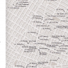
Source: Adrian Kitzinger (cartography) and Ben Singer (research), “Nickeloden theaters on the Lower East Side, c. 1910,” in Entertaining America: Jews, Movies, and Broadcasting, eds. J. Hoberman and Jeffrey Shandler (Princeton: Princeton University Press, 2003), 25.
Movies-02.png
 Download image (1.21 MB)